A challenging ride through Rutland County that involves a few gut-busting climbs and one gnarly Class IV Road
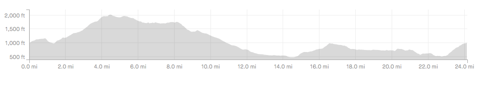
Chittenden, Vermont | 25 Miles | 2,742 ft elevation gain
This ride is beautiful any time of year, but we were fortunate enough to do it during peak foliage season. If you get the chance to do the same, we highly recommend it! No matter when you do it, make sure to bring a proper gravel bike with you because a road bike would definitely not be able to do a sizeable section of this route.
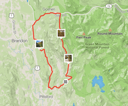
We were visiting family in the area so we were able to start at their house, but you could start at the Park and Ride at #3 Middle Rd in North Chittenden. From there, you begin the toughest climb of the route that lasts roughly three miles. Some of this ascent is steady and gradual, but there are a couple of spikes in grade, including a quick section of 18%!
Once at the top, you’ll find yourself at the end of the hard-packed gravel and the road will become a Class IV under the name “Legal Trail 1.” The trail starts off easy enough, but the further in you go the choppier it gets! We went during a relatively dry spell in the area, yet there were still multiple sections of the trail when we had to pick up our bikes and trek across deep puddles of water overflowing from the nearby swamp. The scenery, however, is unbeatable. We only came across one other person in the 4 miles that we were in the woods and it was incredibly serene. Again, we have to stress that for this route you really need a bike with thicker tires- preferably 38mm+.
Once the Class IV ends, you come out onto Gap Rd, part of the Brandon Gap. Luckily, you’ll be going down the gap, not up! This four-mile descent is a lot of fun due to some smooth pavement and beautiful views. Enjoy!
After you turn off Gap Rd onto McConnell, you’ll be back on gravel and gradually heading back up to where you came from. Once you hop onto Sugar Hollow Rd, you’re on what might be the most beautiful part of the ride. A few rolling hills, a gorgeous pond, and the Green Mountains in the background make this a very pleasant section.
The last couple miles of the ride are, you guessed it…back up! Like the first part of the route, the climb is somewhat relentless but this time about half the length. Luckily, you’ve had some time to rest your legs so you should be ready to end on a high note.
Though it is an incredible ride, the area is quite remote and there are no good rest stops. We recommend bringing enough nutrition and water for the full 25 miles.
Check out the route here: https://www.strava.com/activities/2783775723
